Natural Cartography
The Natural Cartography© allows to read and memorize target directions without the imperative involving of the left brain hemisphere..
The convention for this invention is as follows:
Around a centrum m0, the horizon is divided in 12 directions m1 to m12, whereas m12 points to north.
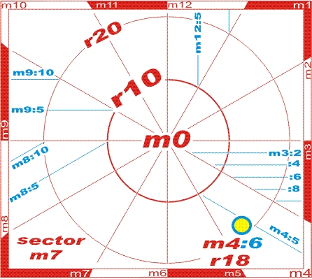 |
These directions are called horizon hours and are divided in horizon minutes, as a distance (not as an angle!) to the horizon hour. The convention is simply: the greater, the later. for example m3:8 is later than m3:4 |
Considering the distance to m0 - the radius -, logical position codes StatusQuo© for targets, crossings, stations etc. come into existence, e. g.
StatusQuo© m4:6 r18
Examples:
| Germany | Europa | Nord- u. Südamerica | Arabia | Africa etc. | Asia etc. | India etc. | Australia etc. |
| alphabetical | A B C D E | F G H I J | K L M N O | P Q R S T | U V X Y Z |
|
. |
The characteristics of such innovation are:
- allows to find target on maps like on reality. : if you imagine to look outwards, right hand will be "to later" (clockwise)
- square grids, indexes and scale indications become o b s o l e t e.
- allows to address targets outside of the map, e. g. m6 r30 on map above.
- makes smarter: animates to build target angles by quantification of the horizon in 12 (instead of 8, 10, 16 or 360) directions, see www.quovides.com
- allows to read position codes StatusQuo© which can appear on navigation aids including mobile phones www.volksnav.com/mobile and on signage as a target code, crossing code www.volksnav.com/lollipop, station code www.volksnav.com/TeheranMetro etc.
- usage indoor, outdoor and global, see www.watchrose.com, resulting on natural world co-ordinates which are adequate for a worldwide reform of the postal codes.
- covers a gigantic market gap: logical and easy understandable position codes
- this simple grid change eliminates weakpoints described on Toxic Maps