A magic grid - the end of the postal codes?
Scope:
A search grid is a helpful tool for finding targets on maps. Conventional square grids aren’t scalable, because of that they aren’t compatible with the zoom facilities of modern online and mobile applications. In practice, the simple question „where?“ is answered with „here!“.
Looking for a method to reform the house numbering in Japan, it was discovered that a similar solution can cover this huge market gap. The innovative grid bases on imaginary clocks and has almost magical characteristics, e. g. the harmony between imagination, signage, cartography, search engines, modern postal codes, coordinates, navigation devices etc.
Market gap:
In combination with an index, a search grid is a tool which helps to find targets on a map. Unfortunately, a conventional square grid A, B, C, 1, 2, 3… can be scaled only within a small range. The maps on modern online and mobile applications can be zoomed almost without limitations, because of that state-of-the-art maps have no such finding tool. Acc. to Fig. 1, the simple question „where?“ is answered with „here“, with names and/or geographical coordinates.
To be able to walk even the first step in the direction of a target, the map user must get an answer to the question „whereto?“. Consequently, he needs twice the information ”where” and even with a square grid the actual cartography doesn’t help on that. The user mostly has to memorize a long chain of right/left commands. In case of a right/left confusion – a normal event – the chain will be interrupted and an orientation collapse will arise.
Fig. 1 is a humorous illustration of maps as they typically appear on metro stations etc. The maps are almost always positioned on vertical surfaces, consequently another problem arises: the north arrow – if existing - shows to the sky. North can’t be “above” but has to be ahead or behind, right hand etc. This additional disaccord causes the situation that many people believe that they aren’t able to read a map. The reality is: the actual mapping system is confusing.
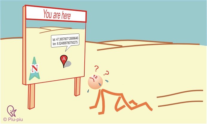 |
Fig. 1 Orientation map
|
Also actual navigation devices cause a degeneration of our natural orientation instinct: the user loses the capability to guide others and to give an answer to the question „where are you?“ on emergency cases.
The innovative solution: a clock based grid
Most residents and tourists in Rio de Janeiro navigate instinctively around the Christ statue, that means:
- inwards / outwards
- clockwise / counterclock
This is a polar orientation. At the other side, soldiers, boy scouts, blind people, pilots etc. divide the horizon in 12 directions for more than 100 years. Consequently, the centering of an imaginary clock on a relevant urban point was analyzed as the missing link. After many surveys on some continents, the following solution arised within a so-called Munich Orientation Convention:
- Horizon hours:
Around a pole m0, the horizon is divided into 12 directions m1 to m12. m12 is the direction from m0 to north and this method divides the building / the city / the nation into 12 sectors. These “clock” sectors are called m-sectors.
- Radius:
Circles around m0 give information about the distance to the pole.
- Horizon minutes:
The sectors are subdivided with lines which give information about the distance to the horizon hour. As the “minutes” aren’t angles, the whole grid isn’t exact polar. This form is called quasipolar.
Fig. 2 shows such a grid for the city of Salzburg, in this case centered on the castle. The red symbol with the inscription “r50” on sector m6 addresses the circle of all targets with a distance of 50 x 100m from the castle. The blue line on sector m6 with the inscription “:25” addresses all targets in a distance of 25 x 100m from the horizon hour m6. This is the line m6:25.
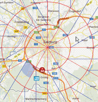 |
Fig. 2: quasipolar search grid as a hard copy from volksnav.de/UniSalzburg |
Amazing characteristics:
The innovative grid has almost magic characteristics, which are explained basing on fig. 2 as follows:
- interface to the reality
The grid allows to find targets on maps like in reality: if the user imagines to look outwards (the pole is behind), right hand on map and in reality will be clockwise, respectively to later.
- Interpolation
Basing on the circles r50 and r100, the grid allows to imagine for example the position of r65. The same is valid for horizon minutes, e. g. the position of m6:10 basing on m6 ( = m6:0) and m6:25
- Extrapolation
It is also possible to imagine the position of targets outside of the map, e. g. m6 r200. Other than today, a map can be helpful even if the target isn’t on map.
- Zoomable
The grid can be zoomed without any limitations. Depending on the zoom level, the grid generator software will draw either r20, r40, r60 or r50, r100, r150 etc.
- Quads with orientation sense
Shown as a blue area on sector m7, the grid contains quads which are similar to the conventional ones. The bended sides of the quads let immediately detect the direction of the pole, even if the pole would be outside of the map. This characteristic is most important for location maps.
- Convertability
All position codes can be converted from geographical coordinates. Because of the earth bending and the quasipolarity, the algorithm is most complex, see volksnav.de/UNmapplet. The algorithm establishes a harmony between navigation devices, mobile phones, signage, cartography and imagination.
- New information
Logical and clickable position codes arise
- for real estates, crossings, stations, stop points, bridges etc. on an urban level,
- logical room numbers on an indoor level
- and addresses for towns, road exits, etc. on a global level.
The system is considered adequate for a worldwide harmonization of the postal codes. Also square grids get obsolete.
Unlimited
The „clock“ has no limitations, so administrations and users can influence where to end the logical addressing.
- Education and safety
The system sharpens the orientation sense, eliminates weak points described on volksnav.de/mapDanger and facilitates the communication, e. g. through loudspeakers, megaphones or mobile phones. It also animates to build target angles by quantification of the horizon in 12 (instead of 8, 10, 16 or 360) directions, see quovides.com
- VolksNav(c)
The resulting quantification of positions allows to navigate at any scale as elegantly as in Rio de Janeiro around the Christ statue: inwards/outwards and clockwise/counterclock. Another invention called vertical pointing allows to detect the directions north and pole.