VolksNav in Cameroon, starting with urban radius r100
Click a red or green circle to discover the national city code of the clicked area.
The blue area shows a quad 100 x 100km. The bended sides "point" to the national pole CM r0.
The definition of the radius r100 allows to build national, urban and indoor location codes based on imaginary clocks which are smarter than room numbers, post codes or other alternatives. They look like this urban example:
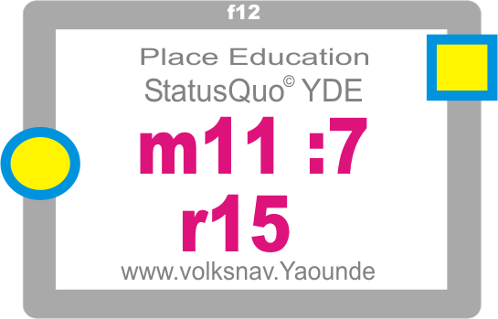
| StatusQuo Yaounde m4:7 r22 |
This target could be a building, a crossing, a stop point, a bridge etc. within Yaounde. The conventions for this format with hours, minutes and radius are as follows:
StatusQuo(c) |
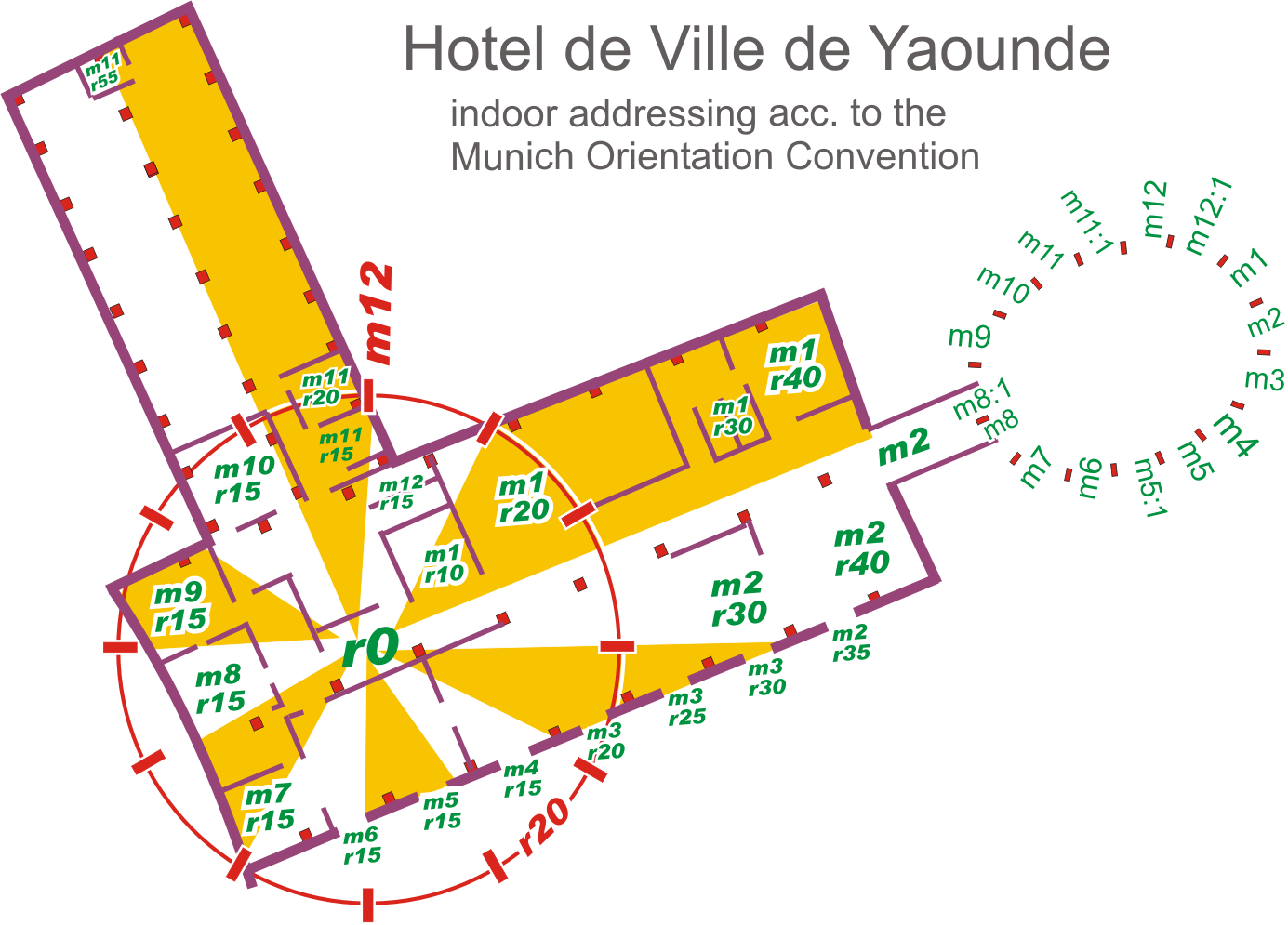
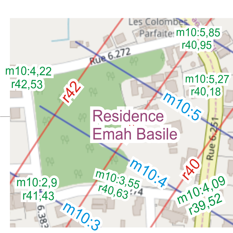
prefix of a location code | Bases on an relevant point called r0, the urban pole. Example Yaounde: place A. Ahidjo |
m12 |
basic horizon hour | This is the direction from urban pole to north. m3 will be to east, m6 to south etc. These direction lines divide the city like a cake into 12 m-sectors. |
number after the " : " |
horizon minutes | This is simply the distance to the horizon hour 1 unity = 100 meters. |
r... |
radius |
This is the distance to the pole. 1 unity = 100m. |
For more datails, see: Urban systems:
1 Yaounde CM r0 - 2 Douala CM m9:20 r200 - 3 Bamenda CM m10:130 r278 - 4 Garoua CM m12:210 r640 - 5 Maroua CM m12:315 r81 - 6 Kousseri CM m12:390 r994 - 7 Ngaoundere CM m1:52 r450 - 8 Kumba CM m9:90 r245 - 9 Loum CM m9:100 r220 - 10 Menengouba CM m10:21 r228 - 11 Limbe CM m9:17 r256 - 12 Edea CM m8:80 r168 - 13 Foumban CM m11:46 r220 - 14 Mt.Cameroon CM m9:42 r263 - 15 Bafia CM m11:23 r105 - 16 Bertoua CM m2:50 r253 - 17 Ebolowa CM m6:40 r111 - 18 Kribi CM m8:12 r205 - 19 Sangmelima CM m5:6 r115 - 20 Bafoussam CM m10:98 r218 - 21 Kumbo CM m11:52 r277 - 22 Abong-Mbang CM m2:82 r186 - 23 Yoko CM m12:91 r208 - 24 Bankim CM m12 r248 - 25 Mbouda CM m10:103 r242 - 26 Ngaoundai CM m1:23 r350 - 27 Ndiki CM m10:50 r126 - 28 Wum CM m11:4 r324 - 29 Mokolo CM m12:253 r806 - 30 Nanga-Eboko CM m1:37 r132 - 31 Lagdo CM m12:243 r626 - 32 Dschang CM m10:73 r240 - 33 Mora CM m12:290 r850 - 34 Yagoua CM m12:420 r830 - 35 Rey Bouba CM m12:302 r612 - 36 Tchollire CM m1 r585 - 37 Tigneré CM m12:127 r411 - 38 Banyo CM m12:32 r324 - 39 Tibati CM m12:125 r316 - 40 Meiganga CM m1:117 r427 - 41 Batouri CM m2:102 r322 - 42 Yokadouma CM m3:36 r395 - 43 Salapoumbe CM m3:140 r450 - 44 Yabassi CM m9:70 r184 - 45 Guider CM m12:270 r727 - 46 Kaélé CM m12:328 r767 - 47 Ntui CM m12:12 r67 - 48 Monatelé CM m10:22 r57 - 49 Eséka CM m8:20 r85 - 50 Fundong CM m11:17 r302 - 51 Makary CM m12:322 r1022 - 52 Darak CM m12:305 r1050 - 53 Mindourou CM m3:32 r212 - 54 Loumié CM m3:77 r246 - 55 Ngoyla CM m3:140 r310 - 56 Ndokayo CM m1:163 r343 - 57 Garoua-Bolai CM m1:180 r405 - 58 Akom CM m7:35 r157 - 59 Ambam CM m6:27 r165 - 60 Bafang CM m10:52 r207 - 61 Bangangté CM m10:70 r180 - 62 Akonolinga CM m3:8 r77 - 63 Awaé CM m2:16 r41 - 64 Mundemba CM m9:128 r314 - 65 Mbalmayo CM m6 r38 - 66 Nkambé CM m11:73 r317 - 67 Njolé CM m12:48 r117 - 68 Touboro CM m1:150 r608 - 69 Nganha CM m1:30 r480 - 70 Obala CM m12:2 r35 - 71 Mamfé CM m10:62 r322 - 72 Molundu CM m3:205 r457 - 73 Poli CM m12:192 r548 - 74 Waza CM m12:340 r904 - 75 Tcheboa CM m12:185 r605 - 76 Mbalam CM m4:30 r313 - 77 Djoum CM m4:50 r185 - 78 Mintom II CM m4:15 r236
---------------------
| National Codes, free | www.volksnav.cm/NationalCodesFree |
| Download free Windows converter | www.volksnav.de/converterCameroonFree.exe or www.volksnav.de/CameroonConverterFree.txt (rename to .exe) |
download KML files for National Codes |
circles | hours | minutes |
Street signage:
 |
This place is on sector YDE m11, Distance to m11-direction: 7 x 100m . Distance to center of town: 15 x 100m, Center of town is in direction f9/left hand North is in direction f2 |
-------------
Version with advertisement (lollippp)
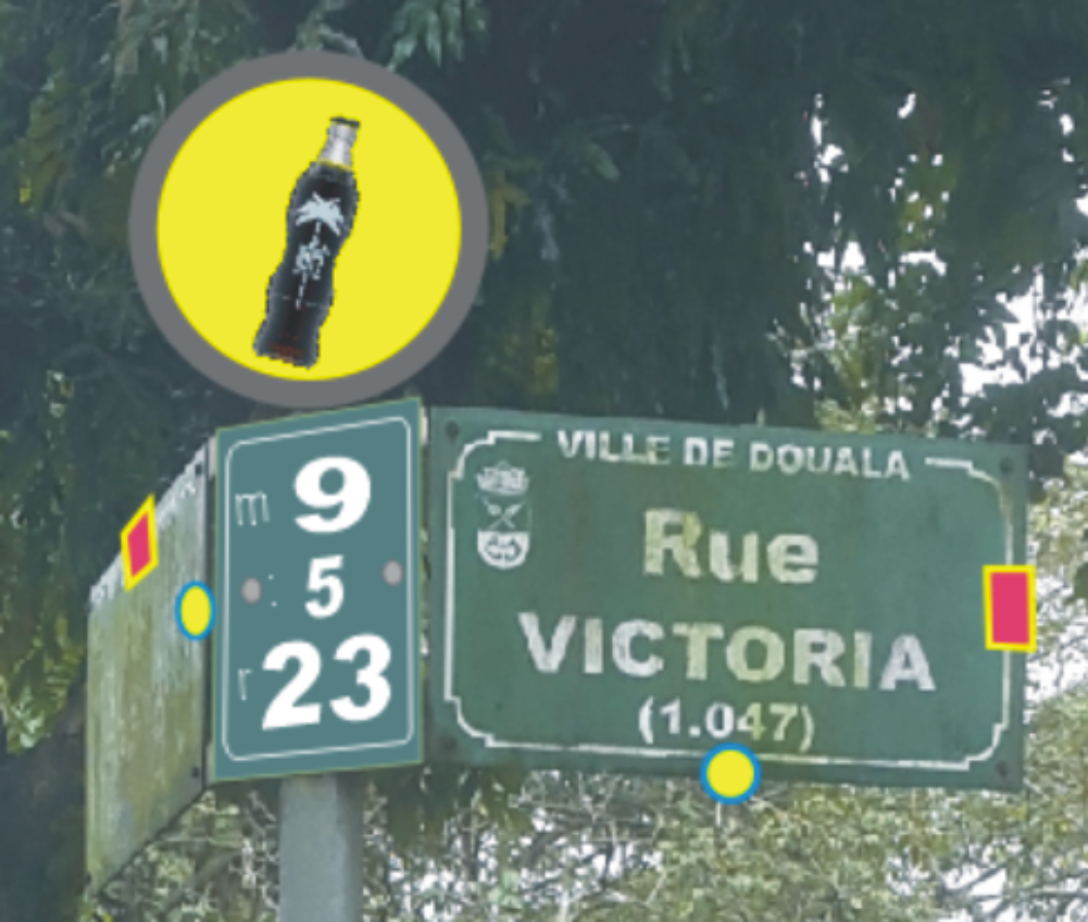 |
Crossing code m9:5 r23, north is right hand (red), downtown is behind (yellow/blue) ------------------ |
Modern house number with 8 benefits:
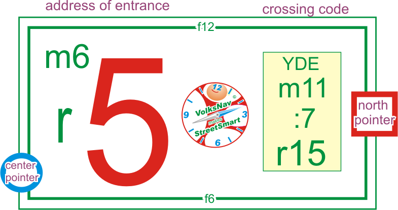 |
Crossing YDE m11:7 r15 is right hand This sign is situated 5m from the crossing in direction m6/south. Center of town is in direction f8 North is in direction f3 |
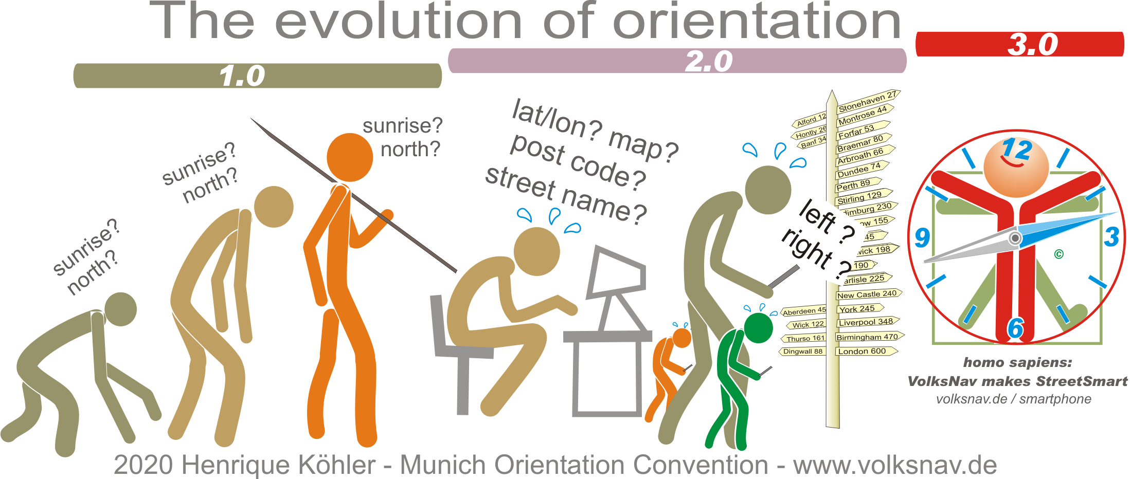
Evolution: