Munich
Orientation Convention in Athena
google
mapplet
Athena has the option to be
world's first city that has realized an international orientation standard, an
idea from a Munichian inventor to simplify and
harmonize worldwide all orientation means: signage, cartography, postal codes, navigation
devices and verbal expressions.
Within this city, it is (will be) possible to find any target with easy brain
work, that means
| -
without maps, |
-
without names, |
| -
without illogical numbers
|
- without
arrows |
| - without
floor marks
|
- without
square grids
|
| - without colors |
- without
compass or other navigation
devices
|
Buildings,
crossings, stop points, bridges etc. have logical
addresses like
Horologium
StatusQuo©
Athena m12
r3
Peace
and Friendship stadium
m8 r40
Lycabbetus
theatre
m1:8
r22
which are easy to
understand if you associate the city with a clock as follows:
|
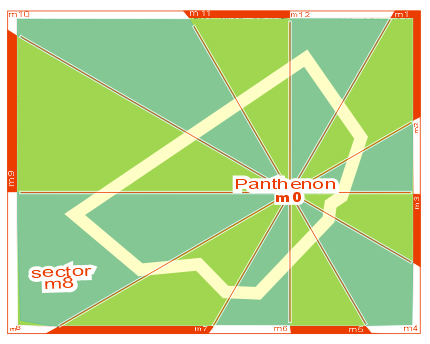
An outstanding point as e. g. the
Panthenon was
(will be) defined as a pole
m0.
Around this pole, the
horizon is divided in 12 "horizon hours"
m1 to
m12
, whereas m12
points to north.
This divides the city as a
cake in 12 imaginary sectors. As an example, the sector m8 was marked.
|
 |
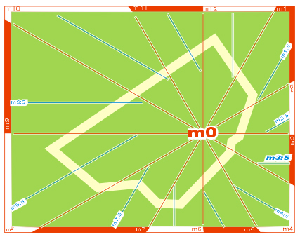 |
The sectors are divided in horizon minutes.
These are not angles but DISTANCES to the horizon hour, in steps
of approx. one "block of houses" or 100 meters.
Example
m3:5 ( read "emm
3 point 5"
or "emm three 5" ).
This is a line situated in a distance of 5 x 100m from the
horizon hour m3, which points to sunrise.
The convention for horizon minutes is very
simple:
the
greater, the later.
|
|
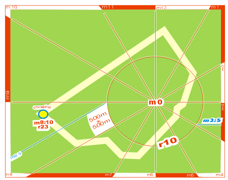
Considering the
distance to m0
as r = radius also in steps of blocks of houses, logical position codes
for targets, buildings, crossings etc. come into existence,
e. g. as shown on the picture:
crossing StatusQuo©
m8:10 r23
StatusQuo means "where you are". In simple words:
"r" is a numbering
starting FROM m0,
"m" is a
north-direction-based numbering AROUND m0
and this simple methode covers a
gigantic market gap:
l o g i c a
l and easy understandable p o s i t i o n
codes.
|
 |
Natural Cartography©:
a map with such a polar grid has innovative
characteritics, see www.volksnav.com/map .
Please be aware about the fact that if the target isn't on map, with the help of
the logical position code it's possible to imagine where it is situated !!
Interesting details:
- the search grid contains quadrangules similar
to the conventional ones. The picture above shows a white quadrangule with the
dimensions 500m x 500m. The bended sides let know in which direction the urban
pole is situated, even if the centre isn't on map.
- the width of the sector is half the radius !! Example:
m8:5 r10, m8:10 r20 etc..
- the middle of the sector is radius/4. Example:
m8:5 r20
.
Signage:
StatusQuo© addresses will be integrated
within the existing signage, see www.volksnav.com/lollipop,
or be indicated on so-called Orientators©, the
signage of the future.
Vertical Pointing©: additional to the
position information, a round symbol called center or pole pointer will be placed on their periphery
to allow to detect the direction m0 according to the following
conventions:
| if the pointer is
placed |
on top
(f12) |
m0
will be |
in front of you
(f12) |
| |
on bottom
(f6) |
|
behind
(f6) |
| |
right hand
(f3) |
|
right hand
(f3) |
etc. Acc. to the same convention, a
square symbol points to north = m12. The picture reveils: m12 is
behind, the pole is right hand
|

Orientator©
|
Navigation / VolksNav©:
The local navigation with the help of such
codes is called VolksNav©. As
proceeded today with house numbers, VolksNav© is nothing else than the
major/minor comparison between "r" and "m"
values:
Simply proceed according to 1 -2 -3 :
| 1
-
Positioning
|
Turn your body until m0 will
be BEHIND. In this position,
| ahead |
will be |
outwards |
| right hand |
" |
to later (clockwise) |
| left hand |
" |
to earlier |
etc.
Beginners have to turn
physically, after some exercises anyone will be able to do this by
his imagination power. In case you look at
above shown Orientator©, you'd have to turn to left, correct?
|
| 2
-
r-comparison
|
Ask yourself:
must I move inwards or outwards?
( = is the target radius
greater or smaller than the actual one?)
|
| 3
-
m-comparison
|
Ask yourself:
must I move to “later” (clockwise)
or to earlier?
( = is the target m later or earlier
than the actual one?)
|
Let's see an example:
Your target is: Peace
and Friendship stadium m8 r40
If you've lost orientation on named
crossing m8:10
r23,
so you must go
- outwards (radius r40 is more
than actual r23 )
and
- to "earlier" (counterclockwise) (
m8
is "earlier" than the actual m8:10 )
This may seem to be unfamiliar, but the
orientation based on cardinal points is used for some thousand years and
imaginary clocks are used by soldiers, boy scouts, pilots, blind people etc. for
more than 100 years.
 |
In a real situation, VolksNav©
can be learned within few minutes, that means, faster than the most
seeking times. Then you'll be able to navigate everywhere as elegant
as around the Christus statue in Rio de Janeiro, where the idea of a
quantified polar orientation and an orientation standard was born. |
.
Vision:
 |
Mobile applications: Very soon also navigation devices and mobile phones will indicate such
logical position codes and cardinal points , see www.volksnav.com/mobile
You're invited to test the program
for pocketPC/smartphone with/without GPS by means of a download from
www.volksnav.com
|
Natural World
Co-ordinates: the same addressing methode will soon also be used
- indoor www.volksnav.com/deutschesmuseum
www.volksnav.com/airportMUC
and
- within the whole globe, see www.watchrose.com.
Acc. to this, the international City Code of Athena is
WatchRose© m4:380 r15 00
What is that good for? Just comparing the
WatchRoses©, you can imagine distances and directions between 2
locations.
Example:
Monastery of Daphni WatchRose© m4:375 r14 90,
Result of comparison: the Monastery of
Daphni is closer and
"earlier" to Munich than Athen, more
exactly:
- radius 1500 - r1490 = 10 km
closer
- :380 - :375 =
5 km "earlier"
The distance between both locations, the
hipotenuse, will be between 10 and 10+5 km
for advanced users only:
the direction Daphni/Athen (to outside / to
later) is QuoVides® 4, see
www.quovides.com