Toxic maps: actual weak points of cartography
It is a common belief that people, who aren’t able to read a map, are inapt.
The truth is: the reading of a map is a complex procedure and the reader has to get over the following obstacles:
A1 – imaginary transfer needed
The user has to place the map in front of the eyes, that means, the entire map information will always be IN FRONT of the user.
What if the target is BEHIND? Experts ignore that this requires a complicated imaginary transfer which some people don’t diminate perfectly. In a stress or panic situation, even skilled persons can come to wrong transfers, coming to wrong decisions.
A2 – Chain of angles, mostly without reference to cardinal points
Actual maps oblige a translation of the image information into a chain of right/left/ahead commands for the muscles. The memorizing of this information is unfavourable because of the following details:
A2.1- standard basic direction missing
A “to right” or „to left“ information is not a direction but an ANGLE ! Angles always require a reference direction and average people have mostly no option than to use the own FUTURE drive or walk direction for this purpose.
Picture 1 shows two examples memoX and memoY. MemoX is an angle which bases on the future drive direction, memoY bases on a casual direction found on map, e. g. a river. What if the river can't be found because of darkness or fog?
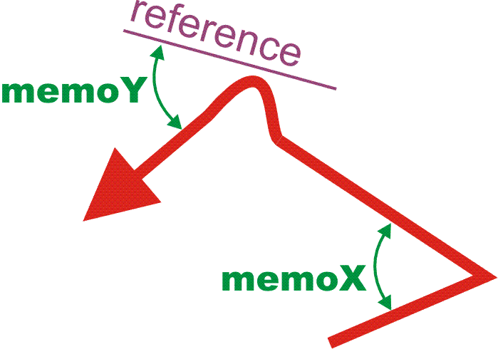
Picture 1 - Memorizing of angles as future muscle commands
Angles like memoX are isolated, that means they have no defined relation to the globe. If any point during the journey the "change drive direction" angle is different than the memorized one (e. g. because of an accident) the whole chain will be interrupted. If it’s not possible to reconstruct the memorized reference direction, the memorized angle can even cause an orientation collapse and disturb a rational thinking.
A2.2 - memory lapse
Most people aren’t able to memorize long chains and will have to read the map during the journey, possibly while driving! (see also chapter A3)
A2.3 - left/right confusion
it is absolutely normal to confuse right and left, also in surgery, see Wrong Leg volksnav.com/wrongleg. Because of that, left/right orientation tools should be avoided.
A3 – Map-to-reality coincidence
The correct reading of maps requires the following steps:
A3.1 - where am I?
First of all it is necessary to find the own location on map. This is absolutely not trivial.
A3.2 - map as a carpet or life buoy
Then it is needed to transfer mentally the map to the body (or body to map) until the own body occupies this point. In this position, the map would be something like a life buoy or a carpet.
A3.3 - coincidence on cardinal points
Then the user must ROTATE the map (or the image on brain) until the cardinal points become identical. With this, e. g. behind on map will be behind on reality.
But how to know in which direction and how many degrees we should turn the map? This is only possible if you are absolutely sure about a reference direction, e. g. the north direction.
This reveals the importance of a compass. Therefore, experts consider compasses antiquate.
A4 – Unnatural square grids A, B, C...
Square grids are tools with very little relation to the reality and only help to find targets on maps. There is no possibility to address targets inside of the grids (interpolation) and outside of the map (extrapolation). Until now, cartographers have been restricted to help finding targets WITHIN the map.
These lines suggest that the world ends "left of A" and "above 1". This is not true.
Another deficiency: as explained before, users need to build an angle between a basic and a target direction. It’s very difficult to imagine an angle e. g. between the grids S8 and B3.
Square grids aren't zoomable.
Much better than square grids are clock based ones, see Magic Grid
A5 – imprinted images aren’t erasable
It’s not possible to hinder an imprinting of image information, at the other side it's not possible to delete it.
Example: let’s define f12 as the front direction (f3 = right, f6 = behind etc.) and let's suppose that according to a map your target is on direction f2. Let's also suppose that according to the road situation you first have to drive ahead (f12) and then turn to the right (f3).
After turning to the right your target will be in front (f12), so It would be necessary to delete the previous image. But nature didn’t foreseen such a command, so nobody knows which image we'd use on unexpected situations. Because of that, maps on navigation devices which rotate according to the driving direction are dangerous. They can cause conflicts on the brain and be the primary cause of mysterious accidents.
B) vertical fixed maps, including emergency maps :

A map should be an image of the reality. If the subject of a vertical fixed map lies horizontal, the map won’t be an image of this subject anymore, it will generate confusion. If the target seems to be “under” the own position on map, the message can’t be that the user has to go underground. To reach this target, he’ll have to walk horizontally, but in which direction? |
Vertical fixed maps cause less confusion if right-on-map is identical to right-on-reality, but almost nobody cares about that.
The invention QuoVides® acc. to quovides.com/map solves this problem .