|
1 general aspects
Two examples for unadequate
orientation are:
- on october 2000 in Hong Kong, the
pilot of Singapur Airlines confused on ground the runways 5L and 5R (left/right). The
guilty parties for this accident are doubtless the persons who have
choosen such grotesque identifiers: left or right from which point of view? Unbelievable,
they didn't know that the pilots use imaginary clocks on air to avoid such
confusions.
- during a tunnel fire in
Munich no person could tell correctly by mobile phone his
position and drive direction, consequently the rescue vehicles lost a
lot of time. How did the authorities solve the problem? They
installed signs with the name of the tunnels; now we have always
to read and memorize them. Concerning the drive direction,
nobody had any idea how to indicate it.
.
Based on innumerable tests and interviews on two
continents, I've developed a comprehensive orientation system which will
revolutionize indoor and outdoor signage worlwide. The
Munich Orientation Convention bases on imaginary clocks, a
methode used by pilots, soldiers, boy scouts, blind persons,
archers etc. already for more than 100 years. Why
shouldn't also everybody be able to use it?
Due to www.volksnav.com/StatusQuo, same methodes can be used for adressing crossings, bus stops, parking spaces, road entrances, taxi stop points, buildings, rooms, emergency steps, fire extinguishers etc. . The adressing with A, B, C, 1, 2, 3, the use of names, left/right, GPS-coordinates will soon get obsolete and acc. to www.volksnav.com/danger be considered dangerious. This system will also make cartography and electronic navigation devices more natural. Follow M contains an orientation esperanto and considers especially the minority groups indicated in www.volksnav.com/TargetGroup as blind persons, deafs, foreigners. Aren't we all foreigners in other countries? QuoVides©, a transparent adhesive film for vertical maps www.quovides.com/map is also a part of the convention and helps to understand the utility of imaginary clocks. Maybe you know the problem: the target which is on the plan e. g. on the right side, can in reality be ahead, behind or even on left side. Vertical maps without QuoVides© may rob your orientation and make you think, you aren't intelligent enough to read maps. The system can be demonstrated in Munich at the Museum of Ethnology, Government of Oberbayern, Englischer Garten, the sport academy of the Technical University, the North Cemetery, Stachus Shopping Center etc. Acc. to www.volksnav.com/brasil, I've given a lecture during the V National Traffic Congress CONATRAN in São Paulo with the title "the Munich Orientation Convention - the life saving signage".
Also remarkable ist, that a degree dissertation acc. to www.volksnav.com/magister
was issued
at the Munich University. www.volksnav.com/brain
explains that women dominate this system more rapidly because they use
the right half-brain for orientation purposes. In the most cases, the
signage is decided by men. Also in your department?
Maybe the most important: the right-to-use
agreement offered in www.volksnav.com/license is
also a membership agreement to an international
convention. Any member can in an unbureaucratic way influence the
convention anytime and get a remuneration for secondary
ideas acc. to §9. The licence fees are quasi-symbolical.
|
||
|
2 - Wesentliches in puncto Orientierung =========== Was Orientierung anbelangt, die wichtigsten Erkenntnissen aus den unzähligen Erprobungen in mehreren Kontinenten sind:
Das Wichtigste ist die RICHTUNG. Egal ob im Auto, als Fahrgast oder Fußgänger, ein Exkurs geht immer über mehrere PoD (point-of-decision), also Stellen an denen der Mensch eine falsche Richtungsentscheidung treffen kann. Schon ein einziger Verlust der Orientierung an einem PoD, beispielsweise an einer Autobahneinfahrt, kann fatale Folgen haben. Die wichtigste Frage am PoD ist: Wie ist die FLUGRICHTUNG (bee line) zu meinem Ziel von hier aus? Kann der Mensch diese mit Sicherheit ermitteln, so weiß er, wie er die Stelle verlassen muß; er trifft die richtige Entscheidung. Diese Frage kann mit Hilfe des Vorstellungsvermögens beantworten werden, vorausgesetzt es ist ein Nullrichtungsgeber vorhanden und man hat sich wenige Minuten Zeit genommen, um zu lernen damit umzugehen.
Zifferblatt-Richtungen sind die einfachsten Die Aufteilung des Horizonts in 12 Himmelsrichtungen ist im Straßenverkehr völlig ausreichend und wegen der Analogie zu einer Uhr äußerst praktisch, unmißverständlich und universal anwendbar. Der Mensch hat in seiner Kindheit mühsam gelernt, aus zwei Zeigerstellungen schlagartig zwei Zahlen, z. B. 8:35h, zu assoziieren: Der umgekehrte Vorgang, aus einer Zahl eine Richtung zu assoziieren dürfte genau so schnell passieren können, also erlaubt das das hier angeregte System die schlagartige Wiederherstellung der Orientierung.
Fazit:: das Wichtigste ist die M-Richtung.
Deshalb meine Anregung: - in der Vorbereitungsphase, ermittle die M-Richtungen - vor Ort Follow M !!!
Wie beim Bedienen der Gangschaltung im Auto entwickelt sich dadurch mit der Zeit einen 6.Sinn der verhindert, daß man die Orientierung verliert. Schon alleine die flächendeckende Ausstattung mit Nordpointern wird die Anzahl der Unfällen, die wegen Orientierungslosigkeit verursacht worden sind, schätzungsweise um 85% abnehmen.
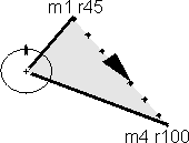
Die Orientierung um einen Pol verstärkt den 6. Sinn, macht Sie also schlauer Beim VolksNav gibt es nur noch 4 Basisrichtungen: ein/auswärts und nach früher/nach später, was die Orientierung wesentlich erleichtert. Die Links/Rechts-Verwechselungen sind damit schon mal ausgeschaltet. Der Vergleich zweier Koordinaten wie im Bild dargestellt, macht es möglich, daß man sich einen Dreieck vorstellen kann, der die zu befahrende Strecke in Richtung und Größe enthält. |
|