.
Natural orientation tools on
airports according
to the Munich Orientation
Convention
mapplet
The Munich airport has the option to be
world's first airport with natural orientation tools, an idea from a Munichian inventor
to simplify and harmonize worldwide all orientation means: signage, cartography,
postal codes, navigation
devices and verbal expressions.
Within this area, it is (will be) possible to
VolksNavigate©, that means to find targets with easy brain work
| -
without maps, |
-
without names, |
-
without illogical numbers |
| - without
arrows |
- without
floor marks
|
- without
square grids
|
| - without colors |
- without
compass
|
- without navigation
devices
|
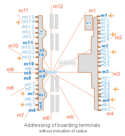
All boarding terminals,
parking places, rooms, lifts,
stairs, emergency exits, extinguishers etc. have logical
addresses like
|
Boarding terminal |
m7:2 |
| Bus
stop |
m9:1 r150 |
|
Parking area |
m2 r40 |
which are easy to
understand if you associate the area with a clock
as follows:
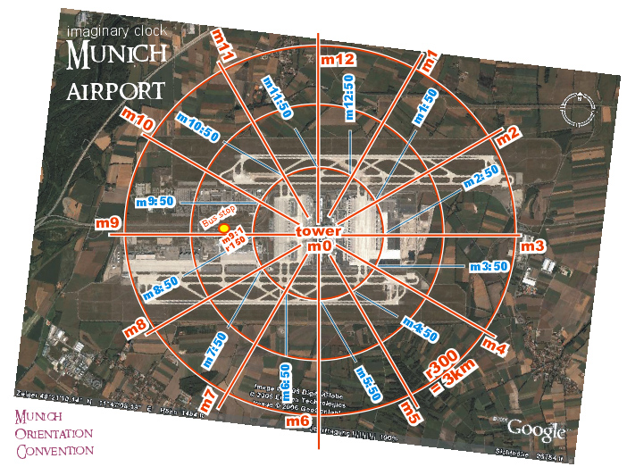 |
The tower is defined as the
centrum or pole m0
Around this pole, the
horizon is divided in 12 imaginary directions
m1
to m12.
whereas m12
points to north. These directions are called horizon hours
Horizon hours are sub-divided in horizon minutes as
a DISTANCE to the horizon hour.
Example:
m3:50
( read "emm
three
point fifty" or "emm
three fifty" )
This code addresses all objects situated in a distance of
50 x 10 meters "later" than the direction m3
The convention for the
minutes is very simple: the greater, the later.
|
Just this simple methode allows to address
boarding terminals logically:
The distance to the tower m0, the radius, is defined as the r-code. Joining this
code to the m-code, logical position indications called StatusQuo© (where you are) come into existence, for
example as shown on first picture:
bus stop
StatusQuo© MUC m9:1
r150
There is another stop point with the
address m9 r150. The "minutes" information let
know which one ist "later"
In other words:
"r..." is a numbering
starting from m0,
"m..." is a
north-direction-based numbering around m0
.
This simple methode covers a
gigantic market gap:
l o g i c a
l and easy understandable p o s i t i o n
codes
and allows to navigate around the tower as elegant as in Rio
de Janeiro around the Christus statue.
|
Today, parking areas are addressed like
this:
|
 |
It is proposed to substitute the figures 1 to 27
like this:
| today |
innovative addressing |
| 1 |
m11 r50 |
| 2 |
m11 r30 |
| 3 |
m7 r10 |
| 4 |
m6 r30 |
| 6 |
m12 r30 |
| 7 |
m5 r10 |
| 8 |
m5 r30 |
| 9 |
m12 r20 |
| 20 |
m4 r20 |
| 22 |
m1 r60 |
| 26 |
m1 r30 |
| 27 |
m3 r20 |
The complete numbering would look like this:
Orientator©,
the signage of the future:
StatusQuo© addresses will be
indicated on a so-called Orientator© as shown right
hand.
Vertical Pointing©: additional to the
logical position information, a round symbol called center pointer will be placed on their periphery
to allow to detect the direction m0 according to the following
conventions:
|

Orientator©
|
| if the symbol is
placed |
on top, |
m0
will be |
in front of you |
| |
on bottom, |
|
behind you |
| |
right hand, |
|
right hand |
etc. Acc. to the same convention, a
square symbol points to north = m12. Other symbols for emergency
exits, WC etc. are foreseen.
The picture above reveils: m12
is behind and
m0 , the tower is left hand .
3D-address:
A third code will help to identify floors which
are higher or lower than the ground floor.
The prefix letter "e" as elevation / etage will address
over ground levels, the letter "u" will address underground
levels.
Examples :
room m4 r90 e1
Navigation / VolksNav©:
The local navigation with the help of such
codes is called VolksNav©. As
proceeded today with house numbers, VolksNav© is nothing else than the
major/minor comparison between "r" and "m"
values:
Simply proceed according to the methode P -
R - M :
| Positioning
|
Turn your body until m0 will
be BEHIND. In this position,
| ahead |
will be |
outwards |
| right hand |
" |
to "later" (clockwise) |
| left hand |
" |
to earlier |
etc.
Beginners have to turn
physically. After some exercises anyone will be able to do this by
his imagination power. In case you meet
the Orientator© shown above, you'd have to turn to right, correct?
|
| R -
comparison
|
Ask yourself:
must I move inwards or outwards?
( = is the target radius
greater or smaller than the actual one?)
|
|
M -
comparison
|
Ask yourself:
must I move to “later” (clockwise)
or to earlier?
( = is the target m later or earlier
than the actual one?)
|
Let's see an example:
If your target is: room StatusQuo©
m2 r40
and you've lost orientation on
position m3:3 r80,
so you must go
- inwards ( radius 40 is less
than r80 )
and
- to "earlier" (counterclockwise) (
m2
is "earlier" than m3 )
This may seem to be unfamiliar, but the
orientation based on cardinal points is used for some thousand years and
imaginary clocks are used by soldiers, boy scouts, pilots, blind people
etc. for more than 100 years. On a real situation, VolksNav© can
be learned within few minutes, that means, faster than the most seeking
times.
Visions:
Urban Orientation The same addressing methode will
also be used
within the cities, see www.volksnav.com/munich
instead of the postal codes.
Acc. to this, the logical urban address of the Munich airport is:
StatusQuo© MUN m1
r280
Natural Cartography©: a map with
such a polar grid has innovative characteristics, see www.volksnav.com/map
Natural World
Co-ordinates / international City Codes: the
same methode can be used all over the globe, see www.watchrose.com.
| Mobile
applications:
also navigation devices and mobile phones will indicate such
logical position codes and cardinal points, see www.volksnav.com/london
You're invited to download from www.volksnav.com
the program for pocketPC with/without GPS incl. bluetooth.
|
 |
