WatchRose© - the metrical alternative to Lat/Lon
The average person actually only knows cartesian or geocoordinates as logical position information. Any other alternative is based on names which have been chosen arbitrarily and thus force the need of maps for the reconstruction of the arbitrarity. At the World Trade Center, additional confusion has raised because many rescuers didn't know which one of the towers has been tower 1 or 2.
For this target group, coordinates aren't easy to handle and haven't got practical applications yet. Because of that, they hardly appear on signage, maps, navigation aids or mobile phones. The dolorous truth in the third milenium is: for orientation purposes people only get names and have to convert and memorize this information on brain in right/left information.
This situation changed completely: an inventor from Munich has developed a natural signage based on imaginary clocks, a methode used by soldiers, pilots, boy scouts etc. for 100 years. He asked himself, why shouldn't average persons be able to do the same? In doing so, he discovered that the so called urban codes StatusQuo©. On a global level, the same methode offers a metric alternative to geographical co-ordinates. In this case, the position code is called WatchRose©
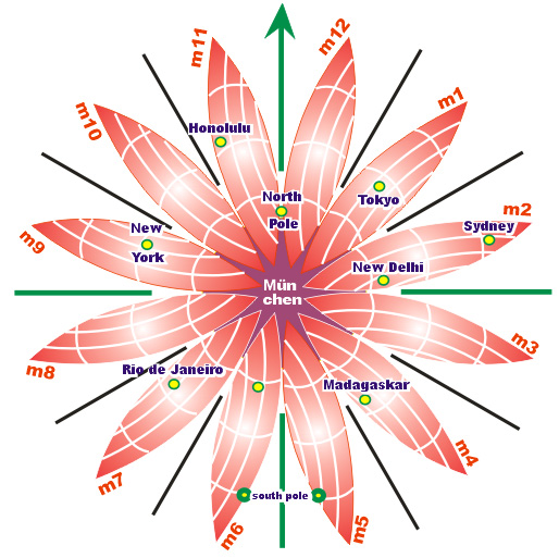
The principle is very simple: the horizont is to be divided around a centrum called m0 into 12 "hour" directions called m1 to m12, whereas m12 points to north, m3 to east, m6 to south etc. The globe was divided into 12 petals with a lenght of 20.000 km and a width of 3.330 km.
The petals are subdivided in "space minutes", which are not angles but simply the "later" km distances to the main direction.
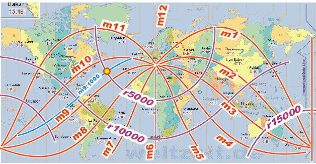
WatchRose© m9:1000 r5000 means, the distance of this target to the centrum m0 is 5.000 km in direction m9 and the distance to this line (m0 to sunset) ist 1.000 km. The same WatchRose© is suitable to appear on signage, on maps and on electronics including mobile phones. WatchRose© m9:1000 r5000 could be an island code:
The local orientation, called VolksNav©, bases on simple major/minor comparisons of the M and the R codes. The capability to read a clock is used in the other direction for orientation purposes: a number means a direction. An elegant time-space convention will be valid worldwide:
if the centrum is behind, right hand will be "to later", ahead will be outwards.
"Orientation" comes from "orient". In the past, people oriented with the orient on rear. This is a kind of pole navigation and this natural methode gets superior when quantified with the help of clock directions. .
The key to electronic applications is a GWAS84/StatusQuo© converter program for urban and a GWS84/WatchRose© converter for global applications. The last one allows to enter the GPS coordinates of any point worldwide. The program indicates the shortest distance to Munich - up to 20.000 km - and the corresponding clock direction. For the target group, this is more logical than angle information based on the two zero directions Greenwhich and equator.
For instance, with mobile phone calls to Munich on each side, everyone can easily determinate the width of a river: its the difference between both text indications.
The use of the system is handled in a very simple way: the rigth-to-use agreement acc. to volksnav.de/license bases on quasi symbolical fees and is at the same time a membership agreement for an international convention. All readers are invited to join the convention.
WatchRose© allows to build City Codes, a kind of international logical area/postal code. Discover the City Code of your city:
A / B / C / D / E / F / G / H / I / J / K / L / M
N / O / P / Q / R / S / T / U / V / W / X / Y / Z
Example:
Tokyo WatchRose© m1:11 00 r93 70
Consequently, the distance between München and Tokio is 9370 km. The first letters are for the rough navigation, the last letters for the local navigation.
These City Codes are e. g. compatible to a worldwide logical numbering of road entrances acc. to volksnav.de/ausfahrt, crossings, bridges, tunnels, disasters etc.. Just comparing these codes with the City Code, it is always possible to know if the city is on front, on left, on right or behind.
WatchRose© - centered on UN
Click here to see the UN headquarters as the global pole.