 |
VolksNav makes StreetSmart©
©2017 Henrique Köhler - Munich Orientation Convention
Notes: Don't forget to calibrate the compass.. On some Android devices, the performance gets better after running first an app like GPSfix. This has to be done just once.. |
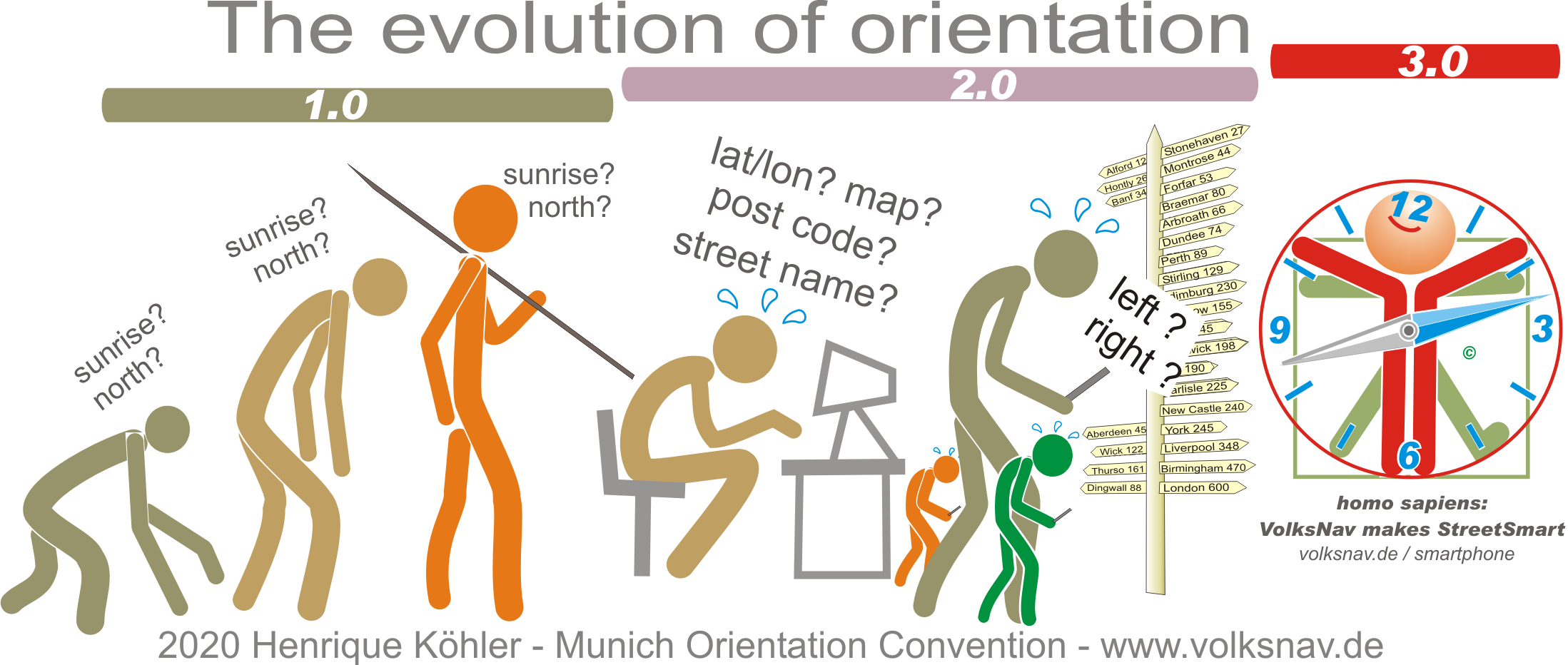
Orientation alarm! Cardinal points got forgotten and human beings degenerated to right/left idiots - and sometimes confuse right and left. VolksNav(c) is the right tool to change this with learning-by-playing.
Did you know that when someone loses orientation in Rio de Janeiro he/she instinctively uses the Christ statue as reference? That means:
- do I have to go inwards or outwards ?
and mainly:
- do I have to go clockwise or counter clockwise?
This is a Time/Space Convention:
- if I look OUTwards, right hand will be "to later". This is similar to "if I look in flow direction, right hand will be the right riverside".
Soldiers, boy scouts, pilots, the blind etc. use imaginary clocks for more than 100 years, why not average people? Because this Convention had relevant gaps.
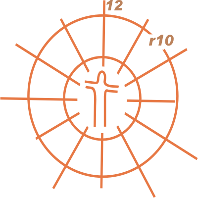 |
In Copacabana I've drawn two circles on the sand and divided them like a cake into 12 sectors. The circles have been named r5 and r10, "r" from "radius". Then I've hidden coins within this "cake" and animated street children to find the coins just with the help of location codes like "4 r7". |
Street children are street smart: they can read a clock and they understand very quickly that r7 must be closer to r5 than to r10. All children have found all coins with just one attempt. A Convention was born which can be used even for international understanding.
The "hours" can be divided into minutes, preferable as a DISTANCE to the own hour line. One unity of radius or minutes corresponds to 1 "block of houses", 100 yards or 100 meters. With this, positions can be QUANTIFIED in that way that average people can understand. I call this a quantum jump.
The last element missing was the alternative to Rio's landmark. After many years, also this challenge has been solved elegantly.
The first line of the app will show an urban location code. This code contains more information than a post code and it will harmonize with future codes for crossings, stations, stop points, bridges, tunnels etc.
VolksNav detects automatically user's city within a scope of almost 500 cities. To find the location code of a target just
- "read" it with the help of the kilometrical search grid,
- tap on map (Android only),
-- or click once or twice this point on the map of the city listed on www.volksnav.de/mapplet
The second line is a worldwide innovation: a compass which lets you know the direction to the center of the city with text(!) and graphic.
With the help of this imaginary Center Pointer, a self-guiding like in Rio will be possible by simple comparison of radius and "time".
With the help of a line reader, even the blind can get StreetSmart.
Now let's declare some Conventions:
| r0 | radius 0 | = city center | ||
| StatusQuo | where you are | = your location | ||
| QuoVadis | whereto you go | = your target | ||
| f-clock | f12 = in front of you |
|
||
| Munich clock | m12 = north direction | either from your body or from r0 |

VolksNav2 shows another innovation: the view direction on map, the so-called QuoVides(R), your actual view m-direction. For example, the expression QuoVides 9 means that you're looking/walking/driving/flying in direction sunset.
So your shoes are like the hours hand of a clock, see also QuoVides(R).
Now let's start playing!
VolksNav(c) |
The following instructions may sound unfamiliar, but after 2 exercises you'll confirm: all this is very easy and VolksNavigation is great.
Very important:
Beginners should first turn the body until they look OUTwards.
 |
All StreetSmarties(c) can achieve this with the help of the Center Pointer: turn the body until the second line shows "r0 = f6". In this position, right hand will be clockwise and ahead the radius will increase. Besides: the sign post shows a futuristic Center Pointer pictogram. |
After this, StreetSmarti will make a major/minor comparison between the actual and the target code.
 |
The actual position on the picture is m7:2 r8 and the "coin" is at m7 r2. The result of this comparison is: "I must go inwards and to earlier". |
Target embracing: divide the horizon into 4 quadrants with your arms.
 |
Depending on the mentioned results, one arm should point inwards or outwards, the other one in target "time" direction. Your target must be within this quadrant, so you could "embrace" it. |
Comparing additionally the values of the codes, StreetSmarties can divide the horizon into 12 directions.
On this example, this will be:
"I must go 600m inwards (8 - 2)
and 200m to earlier,
consequently more inwards than to earlier".
With this new clock around you body, it will be possible to calculate the distance to the target (more than 8 but less than 8+2). Instead of navigating with the urban clock, you could navigate as follows:
BeeLine navigation (ZZ) |
The aerial m-direction to your target is called beeline (BL) and you can define BL with the help of the compass. On following picture, this would be the result:
BL = m10

Let's make an exercise:
which is the BL from the prior example m7:2 r8 to m7r2?
ZigZag navigation (ZZ) |
If it's not possible to follow the BL directly, instinctively you'd go zigzag: sometimes "earlier" than BL, sometimes "later". This can be expressed as follows:
ZZ = m11 m8 m12 m8

Besides: this is also a methode to avoid right/left confusions.
Attention: the compass must be calibrated acc. to producer's instructions, magnetic fields etc. can influence the indication.
As you can see, a life without maps is possible and wise.
Therefore: all described tools are valid with maps and will make it easier to read them, e. g.: "from the subway station in direction m5".
It is recommended to use such tools also on scavenger hunts, orienteering races, geocaching etc.
Exercise:
go one step in direction to your urban address m8:5 r20.
This is the logical address of the famous Oktoberfest in Munich, also called Wiesn (meadows). If you are there, VolksNav2 will automatically switch to the indoor system.
You're invited to visit "Wiesn m9 r25" to enjoy the beatiful panorama.
Besides: the Bavaria statue is a QuoVides(R) 3, she looks to sunrise like the Sphinx and the Christus statue in Rio. The Liberty statue in NY is a QuoVides(R) 5.
-----------------------l